
Infrastructure
Intelligence
Platform
Turning aerial, sensor, and satellite data into actionable intelligence for utilities and public infrastructure.
Who We Are
From data capture to operational decision.
We collect, process, and transform aerial and environmental data into actionable operational intelligence. We do not sell drone flights. We deliver structured, predictive infrastructure intelligence.
Data Sources
Intelligence Outputs

What We Do
Sensor-to-Decision Pipeline
Data Acquisition
Air + Space + Ground sensor capture across multiple modalities
Centralized Ingestion
Unified processing pipeline for all data streams
AI Detection & Classification
Automated anomaly detection, defect classification, and scoring
Risk Scoring & Prioritization
Severity ranking and degradation trend forecasting
Operational Integration
Direct API feeds into SCADA, CMMS, GIS, and dispatch workflows
Core Use Cases
Utilities, Public Sector & Beyond
Our platform serves five major verticals, each with purpose-built detection models and integration workflows.
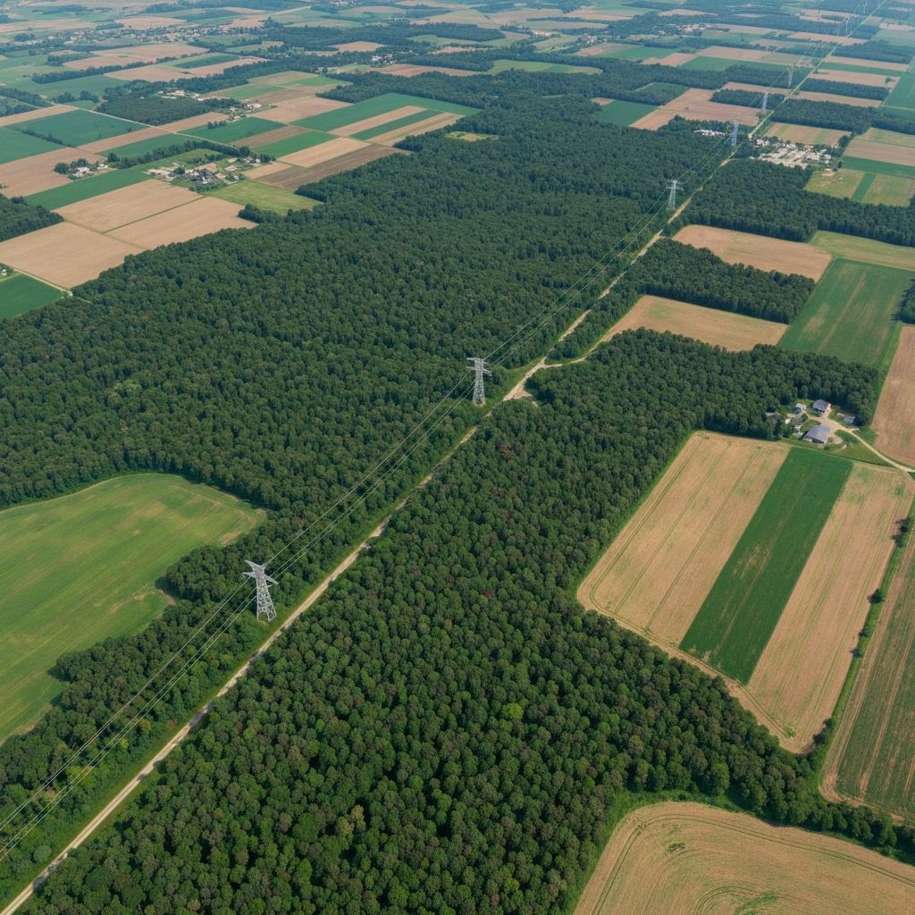
Utilities & Energy
Primary- Powerline corridor monitoring
- Vegetation encroachment detection
- Thermal hotspot detection
- Substation anomaly detection
- Solar plant performance analysis
- Predictive asset degradation scoring
Public Sector
Growth- Illegal construction detection
- Change detection via satellite comparison
- Forestry monitoring
- Structured reporting & GIS integration
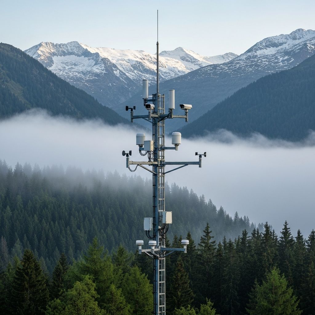
Wildfire Detection
Expansion- Early ignition detection (sensor layer)
- Smoke detection (tower AI)
- Drone-based validation
- Corridor-based monitoring
Illegal Logging
Expansion- Multispectral forest change analysis
- Recurrent satellite comparison
- Drone validation & reporting
Critical Infrastructure
Future- Perimeter monitoring
- Thermal detection
- Intrusion mapping
- Asset change detection

Unique Selling Points
What Sets Us Apart
End-to-End Sensor-to-Decision
We are not a drone service company. We are a data intelligence platform that transforms multi-source data into structured outputs: alerts, risk maps, and predictive models via API.
Competitors sell drone flights. We sell actionable intelligence integrated into operational workflows.
Multi-Layer Detection
Most providers offer a single sensing technology. We combine satellite (macro detection), towers (continuous observation), ground sensors (early detection), and drones (precision validation) with an AI fusion layer.
Faster detection, lower false positives, scalable coverage, optimized cost per km².
Utility-Grade Intelligence
Powered by deep expertise in TSO/DSO analytics, predictive grid modeling, asset registries, and energy trading platforms. Our models are calibrated for powerline maintenance, vegetation risk, transformer anomalies, and solar degradation.
This is a strong vertical moat. Not generic AI.
API-First Operational Integration
Instead of PDF reports, we deliver risk scores per asset, GeoJSON layers, API endpoints, SCADA integration, CMMS integration, and dispatch triggers.
The difference between nice-to-have and mission-critical infrastructure component.
Modular Deployment
Deploy full national coverage, regional pilots, corridor-based monitoring (roads, powerlines), or asset-based monitoring (substations only).
Reduces entry barrier and accelerates enterprise adoption.
Market Positioning
A Fragmented Landscape. One Unified Answer.
Most players operate in isolated parts of the value chain. We span the full sensor-to-decision pipeline.
The Market Today
Hardware Drone Manufacturers
Focus: Flight operations
Docking / Autonomous Providers
Focus: Image capture
Drone Service Contractors
Focus: Manual reporting
Generic Inspection Software
Focus: Dashboard analytics
Our Position
A different category entirely.
Competitive Moats
Six Defensible Advantages
Our moats compound over time, making it harder for new entrants to replicate our position.
01
Multi-Layer Data Fusion
Satellite + UAV + ground sensor data combined into a unified intelligence layer. Competitors operate in a single sensing domain.
02
Predictive Intelligence
We deliver risk scoring, anomaly severity ranking, degradation trend forecasting, and prioritized intervention lists.
03
Sector-Specific Models
Models calibrated for utilities (TSO/DSO), grid corridors, energy assets, solar infrastructure, and regulated public infrastructure.
04
Deep Enterprise Integration
Direct integration into SCADA, CMMS, GIS, asset registries, and dispatch workflows via structured APIs.
05
Data Compounding Advantage
Every monitored asset improves defect classification, seasonal vegetation risk, environmental correlation, and predictive accuracy.
06
Modular Deployment Strategy
Deploy corridor-based pilots, asset-based monitoring, regional or national-scale systems.
Where Industry Leaders Win — And How We Differ
We respect competitor moats while occupying a fundamentally different position in the value chain.
Industry Moats
Autonomous Flight Platforms + Docking
Sophisticated autonomy + fleet operability reduces need for manual pilots
Onboard AI & Autonomous Navigation
Safer operations, less human supervision required
SaaS Analytics & Integration
Turns raw flights into actionable insights at scale
End-to-End Enterprise Integration
Fits directly into enterprise workstreams, not just deliverables
Vertical Expertise (Energy / Utilities)
Contextual models trained on sector-specific failure modes
Regulatory / Certification
Approved secure operational frameworks vs ad hoc providers
Our Differentiators
Multi-Sensor Data Fusion
Satellite + sensor + UAV layered detection (macro to micro)
Predictive Analytics
Anomaly scoring, trend forecasting, risk prioritization
Direct API / Enterprise Integration
Structured deliverables into SCADA, CMMS, GIS
Sector-Focused Models
Domain-calibrated heuristics for utilities & energy
Continuous Monitoring & Alerting
Persistent sensors + scheduled UAV runs = near real-time alerting
FAQ
Realistic Concerns, Clear Answers
Common objections we hear, and how we address each one.

Becoming the Intelligence Layer
for Critical Infrastructure
The Challenge
Manual inspections do not scale. Predictive intelligence does.
Target Sectors
Transforming aerial data into structured, decision-grade intelligence.
Utilities first. Forestry second. Urban monitoring third.
The roadmap is clear. The technology is ready.